What is "Modified
Declination"?
At many web pages,
which deal with how to align a TVRO satellite system, either a big
C-band system or smaller Ku only system, you will see instructions
which suggest that you should set your main rotation axis of your mount
parallel to the earth's rotation axis, and then they give you a chart
or calculator which then gives you a "DECLINATION" angle that your dish
should aim below the plane perpindicular to this axis. This
is basically the same as setting your mount so that the rotation axis
of the motor or mount is at an angle equal to your latitude relative to
the ground, and that the plane perpindicular to this axis is at an
angle of (90-latitude) with respect to the southern horizon.
These web pages usually calculate declination angles that are the
declination angle for a satellite to your south.
However SOME web pages, such as mine, recommend using something
called "Modified Declination", so often the question comes up as to
just what is this modified declination? One good web page
where you can get some good information about modified declination is
the
GEO-ORBIT
declination charts
You will see at that page, declination charts, which differ slightly,
usually by about 0.6 degrees for medium latitudes. The difference
between these two charts is that the regular declination charts were
calculated for sats to your south, while the modified declination is
calculated for sats to your east or western horizon. East or West
declinations are slightly smaller, because you are further away from
these sats, so you don't have to look so far down to see the Clarke
belt.
See the calculator at: http://www.eskerridge.com/bj/sat/bjdishcalc2.htm
At the top of this calculator, you can calculate your declination to
southern sats and to east/west sats, so you can see how they differ.
Below, is a sketch that tries to explain what declination is, and how
it's calculated.
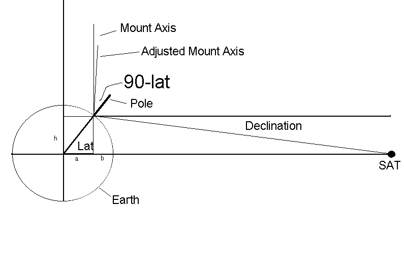
Above, "h" and "a" are sin(lat) and cos(lat) respectively times
the radius of the earth, and "b" is the radius minus a. Then, the
distance to the sat along the equatorial plane is b plus the published
22,236 mile height of the geostationary orbit, which we can call
"c". The declination is then the arctan(h/(b+c)).
This declination, however is only the declination of a sat to your true
south. Sats to your east or west are further away, by up to an
additional "a" amount, so somehow we need to figure out how to track
the arc when the declination needed to follow the arc is different for
each satellite.
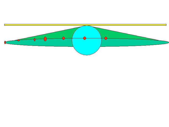
To explain what declination does, imagine that you are at the north
pole. Since the satellites are in a plane defined by the equator,
you have to look down by an angle called declination in order to aim at
the satellites. {Actually you can't see geostationary satellites from
the north pole, but if you could, the diagram below is what it would
look like. Note, the blue circle is supposed to be the earth, and the
little red circles are supposed to be the satellites. You
need to look down via a declination angle to see the sats in the
equatorial plane. The shape swept out by your dish when it
rotates is actually a CONE shape when you have declination. If
you didn't have declination, the dish would sweep out a horizontal plane way
above the equatorial plane described by the yellow in the image below (this
is a plane, not a line as shown in the image. Also see the horizontal line
above the word declination in the sketch above, which represents the dish aime
without declination.
The view from above the north pole would look like the
following diagram. Assuming that you could see
the sats from the north pole, the north pole would be the ONLY place on
earth where the circular cone would hit all the sats perfectly.
Again, the blue circle is the earth, and we're centered on the north
pole.
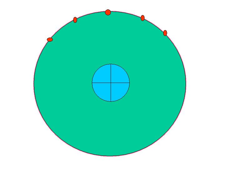
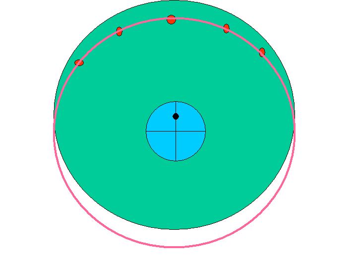
Now, lets move down to some medium latitude instead of showing the view
from the north pole. This is shown below. You will
see that the green circle is smaller because the declination is smaller
as the latitude gets smaller. The problem, however, is that the
circle defined by the declination cone does not hit the sats to the
east or west of the sat dish location, because the declination of those
sats is smaller than the declination of sats to your south, since the sats to
your south are closer to you. The
error can be up to about 1/2 degrees on sats to your east or
west.
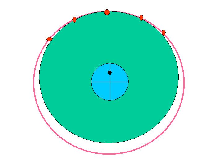
In order to hit the sats to your east or west, it is necessary to use
the declination of an easterly or westerly satellite. However you
see the problem when you do this, is that the cone defined by this
declination will not hit sats to your south. It only hits the arc
to your extreme east/west, and you'd be off by up to 1/2 deg on
your south sat.
The solution is to tip the motor elevation down slightly (by
approximately 1/2 degrees) toward your southern horizon. This
tilts the cone you're sweeping out, so that the projection of the cone
shape describes an elipse where it intercects the equatorial plane,
instead of a circle. You see below how this results in you being
able to track the arc nearly perfectly, within a couple hundredths of a
degree. You notice that when you tilt the motor elevation, it
doesn't change the reception of east/west sats, it only changes the
southerly component of your aim, and it's change is proportional across
the arc, ie more to the south and less to the east/west.
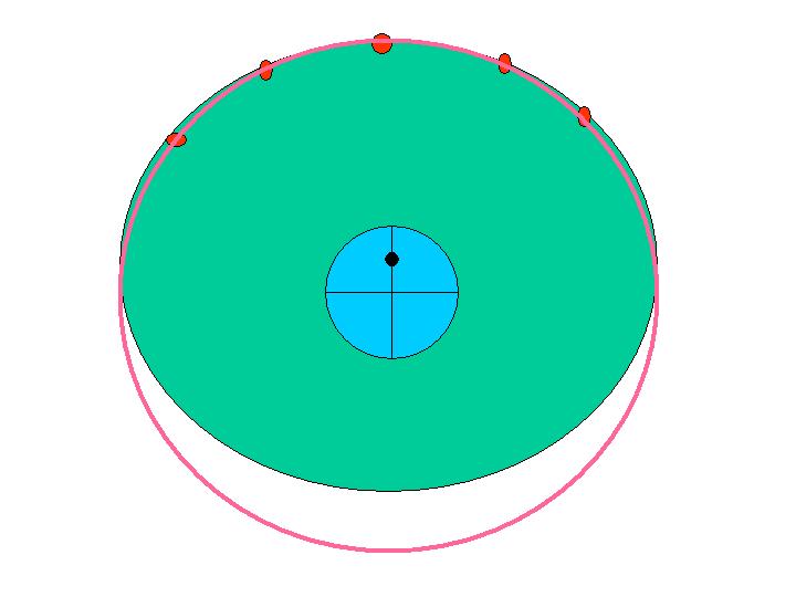
{To be more accurate, the above elipse analogy doesn't really represent
where an extended cone intercects the equatorial plane, which is why I
used the projection term above, and I was referring to assuming that
the cone was finite at the distance down to the equatorial plane.
This would result in the easy to understand eliptical projection. In
reality though, the arc swept by the actual intercection of the
extended cone would be wider than the orbital circle at the
bottom. I know that's confusing, which is why I used the
eliptical explanation, but I thought I should explain that it wasn't
quite accurate.}
But the important concept is that by tilting the axis forward, it
corrects for the 1/2 degree error on the south sats, and the
correction does not affect east or west sats at all, and is applied
proportionally on the intermediate sats, so that tracking is accurate
to at least a couple hundredths of a degree.


